
- Description
Description
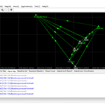
GEOSolution is a software for post processing static or kinematic (also known as stop and go) data. It provides an efficient way for calculating vectors, network adjustment and resultant positions by using GPS, GLONASS, GALILEO and Beidou with single or double frequency. You can get things done easily with the compact and step-by-step interface.
GeoSolution is a software for post processing static or kinematic (also known as stop and go) data. It provides an efficient way for calculating vectors, network adjustment and resultant positions by using GPS, GLONASS, GALILEO and Beidou with single or double frequency. You can get things done easily with the compact and step-by-step interface.
OVERVIEW
- Observation Data: View/Edit observation files
- Time Map: View Observation period, double click on time line to see satellite quality details
- Plane Map: View observation stations plane map
- Baseline List: View/Edit baseline information
- Repeated Baseline: Double click to view repeated baseline detail
- Close Loop: Double Click to view close loop detail
- Adjustment Report: View adjustment report
- Adjustment Coordinates: View coordinate result
SPECIFICATIONS
- 1. Obtain high accuracy position results in areas where real-time corrections are not available
- 2. Support standard RINEX format from any GNSS receiver
- 3. Static and kinematic data processing modes
- 4. Support network adjustment
- 5. Large set of predefined coordinate systems
- 6. Download and process IGS data
- 7. Support GPS, GLONASS, BeiDou, GALILEO
- 8. Coordinate export formats: dat, dxf, kml
- 9. Export baseline and network adjustment report
- 10. Interact efficiently with Hemisphere SurPad android data collection software


