
- Description
Description
The system consists of a CORS subsystem, a communication subsystem, a data center and a user subsystem, providing high-precision positioning and timing services for surveying, monitoring, machine control, GIS meteorology, earthquakes, and smart cities.
OVERVIEW
- 1. Multi-Constellation and Multi-Frequency
With 366/800 channels of GNSS tracking, the Net20 Plus provides stable and reliable accuracy. All GNSS signals come standard including GPS, BDS, GLONASS, GALILEO, QZSS and SBAS - 2. Rich Data Interface
The Net20 Plus supports multiple data interfaces such as serial port, 1 PPS, and event to demand in various applications. Featuring the powerful Linux system to ensure smooth operation. - 3. Rich Wireless Communication
Send and receive data through Wifi, Bluetooth, Ethernet or SIM Card. - 4. L-band Atlas
Atlas is a service to provide global precision correction service over L-band satellites. With ATLAS you can achieve centimeter accuracy WITHOUT any base station. - 5. Large Battery
The 13600mAh battery provides up to 12 hours to respond to emergencies and ensures data is stored safely. - 6. Memory Storage
Includes plenty of room for data storage with 32GB internally and TF card expansion. This also supports FTP push to make data management more convenient. - 7. Smart Alert
Alerts the user through SMS text message or email once the charger is disconnected, battery level is low, temperature is too high or storage is almost full so you never get caught unaware. - 8. Web UI
Gives you the ability to view position status, set up working mode, download data and update firmware from Web user interface with any phone, tablet or PC. - 9. Rugged Design
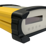
The Net20 Plus main body is built using aluminum alloy materials to provide strong shock and vibration resistant characteristics. IP67 certification ensures operation in tough environments.
SPECIFICATIONS


